Elementor #10464
Serengeti-Mara ecosystem lost an estimated 40 percent of its original area (approx. 30,143 sq. km in 1910) by the 1990s.
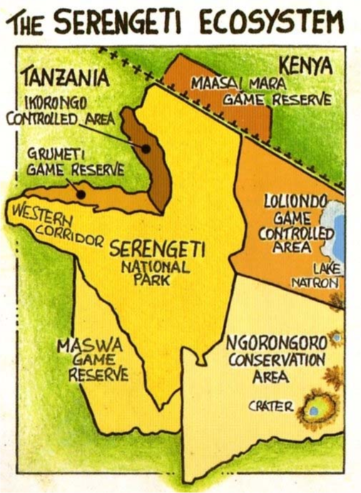
The Serengeti ecosystem spans about 35,000 square kilometers (13,500 square miles), its extent is defined by the movements of the migratory wildebeest.
Core Protected Areas: ~24,565 km² (9,482 mi²) and Buffer Areas: ~11,000 km² (4,247 mi²).
The political administrations included: the main ones in Tanzania are the Serengeti National Park (SNP) itself, and the Conservation Area (NCA), which lies east of the park and includes half of the Serengeti plains. North of the NCA is the district of Loliondo. The Maasai Mara Reserve is the main Kenyan administration. This area holds the vital dry- season grazing and water supplies for the migration. South and west of SNP are small game reserves, such as Maswa, Grumeti, and Ikorongo
There are three major rivers, the most important being the Mara, which originates in the montane forests of the Mau Highlands of Kenya. It has until recently flowed year round, providing the main water supply for the great herds of migrating animals in the dry season. It flows through the Mara Reserve of Kenya and northern Serengeti, and eventually flows west through the huge Musiara swamp into Lake Victoria at Musoma. The two other rivers are the Grumeti, which originates in the highlands of northeastern Serengeti, and the Mbalageti, which originates on the Serengeti plains. Both are seasonal rivers with only pools remaining in the dry season. All other rivers dry out except for a few springs that seep from the base of hills.
Steep, rocky hills occur along the eastern boundary of SNP and between the Grumeti and Mbalageti rivers in the west, forming a backbone to the corridor between the rivers. The Nyaraboro Plateau, with a high (300- meter) escarpment, occurs in the southwest. Because of the generally higher elevation in the east, the hills in Loliondo and the northeast of SNP reach 2,000 meters.
The Serengeti ecosystem is (very roughly) a square, with the treeless plains covering the bottom right quarter, about 5,000 sq. kilometers. They were formed by dust deposits from the volcanoes of the Crater Highlands 4 million years ago.
The ecosystem is effectively self- contained, enclosed by natural boundaries on all but one side. The eastern boundary is formed by the escarpment of the Gregory Rift and the base of the Crater Highlands.
The south is bounded by the edge of the Serengeti plains and in Maswa by the appearance of numerous kopjes (rocky outcrops).
In the west, the corridor, which is largely an alluvial plain formed by the rivers, is bounded on both its south and north by higher ground now agricultural land and by Speke Gulf.
The west side of the northern extension of Serengeti to the Kenya border is an artificial boundary set by agriculture. Within Kenya, the Mara Reserve is bounded by the Isuria escarpment, the Loita plains, and the Loita hills.
The Serengeti ecosystem supports twenty-eight ungulates together with ten large carnivores that eat them. This is an extraordinarily rich and diverse ungulate community. How can all these species coexist with the wildebeest, which outnumbers them all put together and is so dominant that this one ruminant grazer defines the whole ecosystem?